Emerging Revolutionary War welcomes back guest historian Travis Shaw.
Part One
I’d be willing to bet that Maine isn’t the first place to come to mind when you hear the word “frontier”. For many Americans I imagine they immediately think of the wild west. Wagon trains of pioneers crossing the prairies, and Native nations like the Sioux and Apache ranging the plains on horseback. A century before the age of Manifest Destiny, however, the region that is now the state of Maine marked the eastern frontier of the English colonies. It was a wild and sparsely settled place, caught between New England and the French colonies to the north. The few European settlers eked out a living from the thin, rocky soil or turned to lumbering and to the sea. They lived alongside and often fought against the region’s original inhabitants – the Wabanaki or “People of the Dawn.” For two centuries the Eastern Frontier was torn apart by war between various European powers and their respective Native allies. Nowhere is this more clearly evident today than in the small coastal town of Castine, Maine.

Castine or Majabigwaduce as it was then called is located on the southern tip of the Bagaduce Peninsula, which juts into Penobscot Bay near the mouth of the Penobscot River. Early in the seventeenth century the French realized the strategic importance of the peninsula, since nearly all trade and communication in the region relied on access to Maine’s innumerable rivers, bays, and inlets. In 1613 Claude de Saint-Étienne de la Tour built the first French trading post at the location, kicking off two centuries of conflict in the region. Between 1613 and 1763 control of the frontier outpost see-sawed between the British and French (and even the Dutch). With end of the French and Indian War the area came firmly under control of the Colony of Massachusetts as part of the District of Maine. Freed from the specter of French and Native attacks, English settlement slowly moved eastward across the coast.

Peace on the Eastern Frontier was short lived. The coming of the American War for Independence left the settlers of the Maine coast woefully exposed to British raids. The District of Maine itself was divided in its loyalties, as many of the backwoods settlers carried more grievances against colonial officials in Boston than with the British Crown. Through the first years of the war fighting was sporadic on the Eastern Frontier, despite the proximity to the British stronghold at Halifax.
In the summer of 1779, though, the war came to Maine in earnest. On June 12th, 1779 the few settlers living at Majabigwaduce saw strange sails on the horizon, which soon proved to be a British squadron under the command of Captain Andrew Barkley. The small fleet consisted of the Frigate HMS Blonde, the sloops Nautilus, North, and Albany, the brig Hope, and the schooner Arbuthnot.[1] Trailing the warships were a half-dozen transport ships, carrying around 700 troops under the command of Brigadier General Francis McLean. Their mission was to occupy and fortify the peninsula. The bulk of this command (450 men) was drawn from the newly-raised 74th Regiment of Foot, also known as the Argylshire Highlanders. Another 200 Scots from the 82nd Regiment of Foot and some 50 Royal Artillerymen rounded out the force. McLean himself was a 62 year old veteran of the Dutch, Portuguese, and British armies.
What brought such a relatively strong expedition to such a seemingly insignificant place? By this point in the war the main strategic focus for the British was shifting far to the south, but some officers saw the importance of maintaining a toehold in the north as well. Majabigwaduce provided an excellent harbor from which Royal Navy vessels and loyalist privateers could harass New England shipping. Control of the Maine coast also deprived the rebellious colonies of an important source of naval supplies, timber, and fish. There was a political angle to the expedition as well. Massachusetts loyalists Dr. John Calef and John Nutting pressured the British government over the need to create a refuge for New England loyalists fleeing their rebel neighbors. The proposed haven, to be known as “New Ireland” would solidify British control over the region, and should the war go poorly, provide a buffer between any independent United States and the colonies in Canada. Lord George Germain agreed with the assessment, writing the following to General Henry Clinton in 1778:
The tract of country that lies between Penobscot River and the River St. Croix, the
boundary of Nova Scotia on that side, offers itself for the reception of those meritorious
but distressed people. And it is the King’s intention to erect it into a province. As the
first step toward making this establishment it is His Majesty’s pleasure, if peace has not
taken place and the season of the year is not too far advanced before you receive this,
that you do send such a detachment of troops at Nova Scotia, or of the provincials
under your immediate command, as you shall judge proper and sufficient to defend
themselves against any attempt the rebels in those parts may be able to make during the
winter to take post on Penobscot River, taking with them all necessary implements for
erecting a fort, together with such ordnance and stores as may be proper for its defense,
and a sufficient supply of provisions[2]
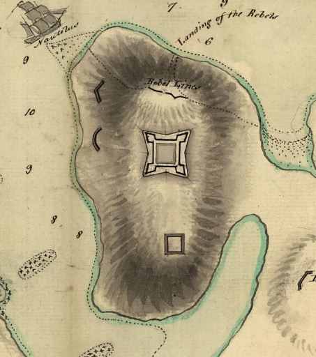
As soon as the British troops were ashore they began to fortify the high ground above the harbor. The primary defense would be a four-basioned earthen fort, Fort George, that occupied the plateau in the center of the peninsula. Several outer works were constructed around Fort George, and an additional battery was erected on nearby Nautilus Island. Convinced that the site was secure, Captain Barkley and the bulk of the fleet departed for the return trip to Halifax, leaving only the Nautilus, North, and Albany. The British soldiers and sailors continued to clear trees and dig entrenchments over the next few weeks, assisted by a number of loyalists who began to arrive from the surrounding countryside. Approximately 500 loyalists took the oath of allegiance at Majabigwaduce. Some provided labor or supplies and even began to enlist in armed militia companies.[3] The local patriots offered no resistance, but it was assumed that a military response would come once word of the landing reached Boston.
*Sources*
[1] Buker, George. The Penobscot Expedition: Commodore Saltonstall and the Massachusetts Conspiracy of 1779. Naval Institute Press. 2002. pg 7
[2] Germain to Clinton, September 2, 1778, Carleton Papers, 1775-1783, Public Archives of Canada. Ottawa, vol. 7, no. 27, pg. 240-41
[3] Leamon, James. Revolution Downeast: The War for American Independence in Maine. University of Massachusetts Press. 1995. pg. 107.

Looking forward to part II. If you haven’t already, check out Bernard Cornwell’s novel, “The Fort” (HarperCollins, 2010), which is based on the Penobscot expedition. It’s not his best work, but he’s famous for attention to historical detail and superb at capturing characters, both of which come through.
LikeLike
Pingback: Disaster on the Eastern Frontier | Emerging Revolutionary War Era
Great post Travis…a topic that is rarely covered. Keep up the great work
LikeLike