Emerging Revolutionary War would like to thank Drew Gruber, for bringing this connection to our attention.
During the May 5th, 1862 Battle of Williamsburg as Confederate soldiers ran down into what would be called the bloody ravine they ran headlong into men from New Jersey, New York, and Massachusetts. In an effort to push the Union soldiers out of the ravine and sweep them from the field brigade after brigade was sent into the fight. Among those was four Virginia regiments under AP Hill. After leaving the relative safely of the City they deployed in some form of a line and pitched down into the ravine too.
In the ravine hand-to-hand combat, fallen trees, driving rain, and the thick smoke made communication almost impossible and command fell on company commanders to keep the battle moving in their favor. Among the men in Hill’s brigade fighting down in the bloody ravine was Tipton Davis Jennings of the 11th Virginia Infantry. His account of the fighting here at Williamsburg will be of particular interest to your readers of the ERW blog.
Writing in 1897 his “Incidents in the Battle of Williamsburg” appeared in the Confederate Veteran Magazine. In fact Kate and I covered this in an earlier ERW post titled, Revolutionary Memory. (click here to read that post).
“Just then,” he wrote, “we happened upon what was apparently an ancient line of grass-grown earthworks. We learned afterward that portions of Washington’s line of entrenchment were yet discernible thereabouts. And so it is possible that we ragged ‘Rebs’ were actually defending the same works were [sic] once stood the ragged continental ‘Rebs’ fighting, the hessian of Europe, as we were now, some eighty years later. So doth history repeat itself.”
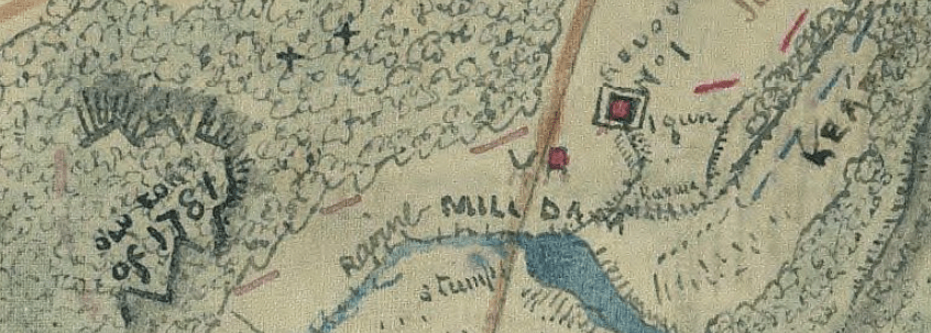
At first glance is this a cool anecdote and yet rather odd. However, when you consult french maps from the Williamsburg region created during the Yorktown Campaign you’ll find references to Mulhenburg’s “lights” camped in this very area. Moreover, almost hidden in plain sight on one of Sneden’s 1862 maps is and “Old Fort of 1781.” Civil War soldiers seemed wholly cognizant of the Revolutionary landscape around them and like Jennings used it to spur on their cause(s).
Yesterday, on the 158th anniversary of the May 5th, 1862 battle the American Battlefield Trust launched a campaign to save the 29 acres over which Jennings charged. Perhaps it is this very same ground where the original cast of “ragged continental ‘Rebs'” also campaigned. Click here to read about that initiative and for further information on how to donate.
